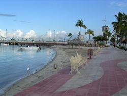
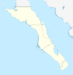
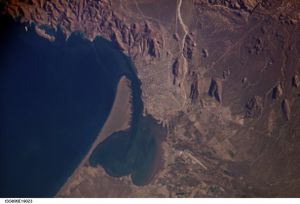
La Paz, Baja California Sur
| La Paz | |
|---|---|
 |
|
 La Paz
|
|
| Coordinates: | |
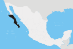
| Country | |
| State | |
| Municipality | La Paz |
| Founded | May 3, 1535 |
| named La Paz | 1596 |
| Government | |
| - Municipal president | Lic. Rosa Delia Cota Montaño (PRD) |
| Population (2005) | |
| - Total | 189,176 |
| Data source: INEGI | |
| Time zone | MST (UTC-7) |
| - Summer (DST) | MDT (UTC-6) |
| Website | http://www.lapaz.gob.mx |
| Source: Enciclopedia de los Municipios de México | |
La Paz (Spanish pronunciation: [la ˈpas], The Peace) is the capital city of the Mexican state of Baja California Sur and an important regional commercial center. The city had a 2005 census population of 189,176 persons, but its metropolitan population reaches roughly 200,000 persons because of surrounding towns like el Centenario, el Zacatal and San Pedro.[1] Its surrounding municipality, which is the fourth-largest municipality in Mexico in geographical size, reported a population of 219,596 persons living on a land area of 20,275 km2 (7,828 sq mi).[1][2]
Contents |
History
La Paz was first inhabited by Neolithic hunter-gatherers at least 10,000 years ago who left traces of their existence in the form of rock paintings near the city and throughout the Baja peninsula. On May 3, 1535, Hernán Cortés arrived in the bay by La Paz and named it Santa Cruz; he attempted to start a colony but abandoned his efforts after several years due to logistical problems.[3] In 1596 Sebastián Vizcaíno arrived, giving the area its modern name, La Paz.
La Paz is featured in the John Steinbeck novel The Pearl (1947) and mentioned extensively in his travelogue The Log from the Sea of Cortez (1951). The city is also the setting of the children's novel The Black Pearl (1967) by Scott O'Dell, chosen as a Newbery Honor Book in 1968.[4]
Climate
La Paz has an arid climate. The climate of La Paz is typically dry, warm and sunny with a year around average of between 23C-25C(75F-77F). Summer months (July-September) are often in the 30C’s(90F's) and can be humid. The winter months (December-February) are the coldest with temperatures dropping below 15C(60F), but mostly in the low 20’sC(68-75F). Breezes from Bahia de La Paz keep the temperature mild. The bay also acts as a barrier against seasonal storms in the Sea of Cortez. Rainfall is minimal, although infrequent downpours can bring heavy rains. La Paz usually averages in with over 300 days of sunshine annually.
During the summer the cooling Coromuel winds, a weather phenomenon unique to the La Paz area, blow during the night from the Pacific over the Peninsula and into the Bay of La Paz.
| Climate data for La Paz | |||||||||||||
|---|---|---|---|---|---|---|---|---|---|---|---|---|---|
| Month | Jan | Feb | Mar | Apr | May | Jun | Jul | Aug | Sep | Oct | Nov | Dec | Year |
| Record high °C (°F) | 31 (88) |
34 (93) |
35 (95) |
38 (100) |
40 (104) |
41 (106) |
41 (106) |
41 (106) |
42 (108) |
38 (100) |
35 (95) |
32 (90) |
42 (108) |
| Average high °C (°F) | 23 (73) |
25 (77) |
27 (81) |
30 (86) |
31 (88) |
34 (93) |
35 (95) |
35 (95) |
34 (93) |
32 (90) |
28 (82) |
25 (77) |
30 (86) |
| Average low °C (°F) | 12 (54) |
12 (54) |
13 (55) |
14 (57) |
16 (61) |
18 (64) |
22 (72) |
23 (73) |
23 (73) |
20 (68) |
17 (63) |
14 (57) |
17 (63) |
| Record low °C (°F) | 2 (36) |
2 (36) |
1 (34) |
6 (43) |
10 (50) |
12 (54) |
16 (61) |
17 (63) |
16 (61) |
13 (55) |
10 (50) |
5 (41) |
1 (34) |
| Precipitation mm (inches) | 0 (0) |
20 (0.79) |
0 (0) |
0 (0) |
0 (0) |
0 (0) |
10 (0.39) |
30 (1.18) |
30 (1.18) |
10 (0.39) |
10 (0.39) |
20 (0.79) |
170 (6.69) |
| Source: [5] | |||||||||||||
Economy
La Paz's population has greatly increased from the 2000 census and now stands at approximately a quarter of a million people. This growth is largely because the city enjoys one of the highest standards of living and quality of life in Mexico, with average wages in the range of $27 USD per day, whereas minimum wages in the country overall stand at closer to $4.25 USD per day. Many of the poorer southern Mexican States' workers often have to work for half of that. For this reason many migrate to La Paz, and other areas in Baja California Sur, to enjoy a better life without leaving the country and still be able to remit portions of their incomes to their families in their home states.
Eco-tourism is by far the major source of tourism income in La Paz as people come to enjoy its marine wonders, as well as its diverse and often unique terrestrial species endemic to the region. There are some 900 islands and inlets in the Gulf of California with 244 now under UNESCO protection as World Heritage Bio-Reserves and the Isla Espíritu Santo group, which borders the south eastern portion of the Bay of La Paz and are considered the crown jewels of the islands of the Gulf (also referred to as the Sea of Cortez/Mar de Cortes), the primary tourist destination of the area. Its diving, snorkeling, and kayaking are considered second to none.
La Paz is also favored by water enthusiasts for its marinas (Paraiso del Mar,[6] Costa Baja Marina, Marina de La Paz (www.marinadelapaz.com), Villas de San Lorenzo, Palmira Marina, and Marina Sur, soon to open) as well as its four boatyards, marine supply stores and cruiser club activities. The surrounding waters are full of adventure for experienced captains. Novice captains enjoy its nearby island coves for day or overnight trips along with a wealth of experienced sailors and boaters willing to share their expertise.
Industries include silver mining, agriculture, fishing and pearls. Tourism is also an important source of employment for this coastal community.
La Paz has recently become an ideal place for retirement. Along with its marinas, a new set of developments are emerging due to its relative closeness to the USA (2 hour flight from Los Angeles), the mild weather, the services the city offers, and the relative peace found in this small city.
When Aero California existed, its headquarters were in La Paz.[7]
Transportation
La Paz is served by Manuel Márquez de León International Airport with flights to the most important cities of Mexico: Mexico City, Guadalajara, Monterrey, and United States, with a flight to Los Angeles. Airlines flying into La Paz include Alaska Airlines, Aeroméxico Connect, Volaris and VivaAerobus. Two ferry services operate from the port of Pichilingue outside the city, connecting the Baja California peninsula to the mainland at Mazatlán and Topolobampo, near Los Mochis.
Roads
La Paz is served mainly by two highways, the highway 1 that links the south of the state from "Cabo San Lucas" to the north of the peninsula until Tijuana, and the highway 19, that connects La Paz with the population of the south pacific towns like "Todosantos" and "El Pescadero".
Also is served by two secondary roads, the "Los Planes" highway that connects La Paz with places like "La ventana", "Ensenada de Muertos" and "Los planes", the other is "Pichilingue" highway which links La Paz with its maritime port.
Education
La Paz is the state capital and center of commerce, as well as the home of the three leading marine biology institutes in Latin America (UABCS, CIBNOR & CICIMAR), largely because it sits on the Gulf of California which is the most bio-diverse body of water in the world. It also supports several other university level institutes of learning.
Sister cities
|
References
- ↑ 1.0 1.1 (Spanish) Link to tables of population data from the 2005 Census, INEGI: Instituto Nacional de Estadística, Geografía e Informática. Accessed on line 15-II-2008.
- ↑ (Spanish) Los Municipios con Mayor y Menor Extensión Territorial, Instituto Nacional Para el Federalismo y el Desarrollo Municipal, SEGOB (Mexico.) Accessed on line 15-II-2008.
- ↑ Chapter 2, vol. 1, History of California, Theodore Henry Hittell, San Francisco: N. J. Stone & Company, 1897.
- ↑ Newbery Medal and Honor Books, 1922-Present, ALSC, American Library Association. Accessed on line 15-II-2008.
- ↑ WeatherBase, accessed 10 March 2009
- ↑ http://www.paradiseofthesea.com
- ↑ "Directory: World Airlines". Flight International: p. 46. 2007-03-27.
External links
- Ayuntamiento de La Paz Official Website of Municipality of La Paz
- Marina de La Paz Best Marina in La Paz B.C.S.
- VivaLaPaz La Paz official vissitors web page
|
||||||||
|
|||||